View the Trail Map
The Old Plank Road Trail, which connects the Chicago Heights and Joliet suburbs, offers views of oak trees, sugar maples, prairie grasses, and wildflowers peeking up through the underbrush.
The trail follows a Native American trail later used by fur trappers and early settlers around Lake Michigan. Business interests later purchased the corridor for a plank road. However, before laying lumber, they decided that a railroad would be a better option. The old Michigan Central Railroad (MCRR) line opened in the mid-1850s and ran through here until the 1970s, connecting East Gary (now known as Lake Station), Indiana, and Joliet, Illinois. It was dubbed the Joliet Cut-Off by observers because it allowed trains heading west to avoid Chicago. Mileage markers still indicate the distance to East Gary.
When the railroad line was decommissioned, trail supporters realised it had unintentionally preserved swaths of natural prairie that had never been cultivated. That prairie growth can still be found along the trail in many places today.
Beginning in Chicago Heights, where the Old Plank Road Trail meets the Thorn Creek Trail, you’ll travel 2.5 miles west to Rail Fan Park in Park Forest, a railroad enthusiast’s dream. The park includes a raised viewing platform from which you can watch north-south and east-west trains on the Canadian National Railway change direction on an elevated interchange resembling a giant cloverleaf while Metra commuter trains pass by.
In about 3 miles, pass through the Dewey Helmick and Old Plank Road Prairie Nature Preserves at the headwaters of Butterfield Creek to look for wildlife. More than 200 prairie plant species thrive here, attracting 170 bird species, including bald eagles and herons. Muskrats, coyotes, and beavers are examples of mammals.
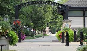
Frankfort, the trail’s physical and spiritual centre, is about 5 miles away. An archway overhead with the trail’s name emblazoned welcomes you. The pathway runs through the community’s historic downtown, with many shops and restaurants nearby. May through October, a bustling Sunday farmers’ market offers locally grown produce and homemade baked goods. The trail ends on the western side of town at an award-winning arrowhead-shaped suspension bridge that crosses US 45.
A 2.2-mile detour past US 45 leads to the Hickory Creek Bikeway (its west branch), winds for 3.6 miles through a forest preserve. It concludes at a trailhead and the site of a one-room schoolhouse from the 1930s in New Lenox.
After rejoining the Old Plank Road Trail, the terrain gradually descends for the next 8 miles to the outskirts of Joliet. Despite passing through a growing residential and commercial area, a forested buffer hides much of it.
Trail Access and Parking
To reach the eastern end of Campbell Ave. in Chicago Heights, take Exit 340 off I-57 for US 30/Lincoln Hwy. After 4.6 miles, turn right onto Campbell Ave. After 0.5 miles, look for parking on side streets near the Old Plank Road Trail crossing. You can also Joe Orr Woods and make memorable events. Are you fed up with pests? Get Atap Exterminators service in South Chicago Heights because they’re available anytime. You can call us at any time at 773-701-7705.